


Château de Mison départ Ribiers + 220

claude nier
User
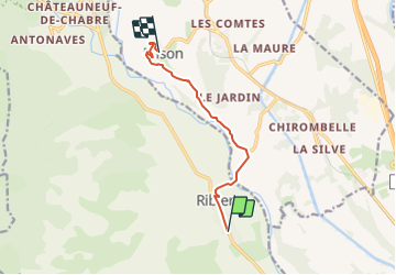

Length
7.6 km

Max alt
658 m

Uphill gradient
209 m
Km-Effort
10 km

Min alt
494 m

Downhill gradient
76 m
Boucle
No
Creation date :
2023-12-12 12:40:01.001
Updated on :
2023-12-12 12:40:02.141
2h16
Difficulty : Medium

FREE GPS app for hiking
 SityTrail
IGN / Geographical institutes
SityTrail Plus
The world is yours!
About
Trail Walking of 7.6 km to be discovered at Provence-Alpes-Côte d'Azur, Hautes-Alpes, Val-Buëch-Méouge. This trail is proposed by claude nier.
Description
petite rando sympa au soleil
Positioning
Country:
France
Region :
Provence-Alpes-Côte d'Azur
Department/Province :
Hautes-Alpes
Municipality :
Val-Buëch-Méouge
Location:
Unknown
Start:(Dec)
Start:(UTM)
728487 ; 4900688 (31T) N.
Comments