Trail Walking Source-Seine - Promenade à Source Seine 11.3km et 220m déniv - Photo

Promenade à Source Seine 11.3km et 220m déniv

© OpenStreetMap contributors
Length
Length
11.4 km
Max alt
Max alt
510 m
Uphill gradient
Uphill gradient
218 m
Km-Effort
Km-Effort  
14.3 km
Min alt
Min alt
412 m
Downhill gradient
Downhill gradient
218 m
Boucle
Boucle
Yes
Creation date :
2023-12-14 14:54:29.307
Updated on :
2023-12-14 14:57:56.79

(0 Reviews)

Walking
Walking
3h14
Difficulty : Difficult

Scan this QR Code to open this trail in the SityTrail application

FREE GPS app for hiking

Logo SityTrail SityTrail

IGN / Geographical institutes

Download SityTrail from the App Store Download SityTrail from Google Play

Logo SityTrail SityTrail World

The world is yours!

Download SityTrail from the App Store Download SityTrail from Google Play Download SityTrail on Huawei AppGallery

About

Trail Walking of 11.4 km to be discovered at Bourgogne-Franche-Comté, Côte-d'Or, Source-Seine. This trail is proposed by eaea7charles.

Description

Départ depuis l'étang de Blessey, 40km au nord ouest de Dijon. Du lavoir de Blessey, prendre la D103C en direction de St Germain  Source Seine

Elevation profile

Positioning

Country:
France
Region :
Bourgogne-Franche-Comté
Department/Province :
Côte-d'Or
Municipality :
Source-Seine
Location:
Unknown
Start:(UTM)
626879 ; 5260893 (31T) N.

Trails nearby

Trail On foot Source-Seine - Promenade Source-Seine - Photo
On foot
PRO

On foot

Easy
Source-Seine, Bourgogne-Franche-Comté, Côte-d'Or, France
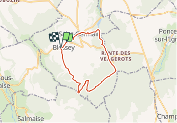
11.3 km | 14 km-effort
3h 11min
Yes
Trail On foot Frôlois - Autour du Ru de Vau - Photo
On foot
PRO

On foot

Easy
Frôlois, Bourgogne-Franche-Comté, Côte-d'Or, France
6 km | 8.4 km-effort
1h 55min
Yes
Trail Walking Poncey-sur-l'Ignon - Les deux sources - Photo
Walking
lolomilastef

Walking

Difficult
Poncey-sur-l'Ignon, Bourgogne-Franche-Comté, Côte-d'Or, France
10.3 km | 12.9 km-effort
2h 56min
Yes
Trail Walking Source-Seine - Sourve de la Seine - Photo
Walking
cmike39

Walking

Very easy
Source-Seine, Bourgogne-Franche-Comté, Côte-d'Or, France
24 km | 31 km-effort
7h 30min
Yes
Trail Walking Source-Seine - Les sources de la Seine et leurs environs - Photo
Walking
ARPF2

Walking

Difficult
Source-Seine, Bourgogne-Franche-Comté, Côte-d'Or, France
12 km | 15.3 km-effort
3h 28min
Yes
Trail Walking Frôlois - Vaubuzin - Photo
Walking
lacabanazaza

Walking

Medium
Frôlois, Bourgogne-Franche-Comté, Côte-d'Or, France
6.6 km | 9.1 km-effort
1h 55min
Yes
Trail Other activity Frôlois - baigneux - Photo
Other activity
tof747

Other activity

Very easy
Frôlois, Bourgogne-Franche-Comté, Côte-d'Or, France
32 km | 42 km-effort
1h 56min
No
Trail Walking Source-Seine - BLESSEY  SOURCE DE LA SEINE - Photo
Walking
Bret

Walking

Medium
Source-Seine, Bourgogne-Franche-Comté, Côte-d'Or, France
11.4 km | 14.1 km-effort
3h 4min
Yes
Trail Walking Chanceaux - Chanceaux a Pouillenay  - Photo
Walking
loupblanc.68

Walking

Medium
Chanceaux, Bourgogne-Franche-Comté, Côte-d'Or, France
28 km | 36 km-effort
10h 10min
No


Close
My subscriptions