


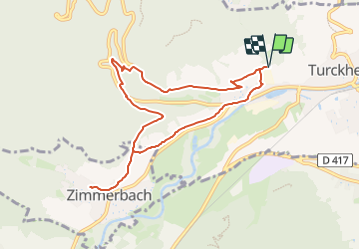
Parking au dessus des Caves de Turckheim - Frauenberg - Dickenloch - Zimmerbach et retour par Dickenloch et Ensenberg

patrickbeyrath
User

Length
8.6 km

Max alt
420 m

Uphill gradient
233 m
Km-Effort
11.7 km

Min alt
245 m

Downhill gradient
233 m
Boucle
Yes
Creation date :
2023-12-15 07:20:51.101
Updated on :
2023-12-15 07:43:23.715
2h39
Difficulty : Easy

FREE GPS app for hiking
 SityTrail
IGN / Geographical institutes
SityTrail Plus
The world is yours!
About
Trail On foot of 8.6 km to be discovered at Grand Est, Haut-Rhin, Turckheim. This trail is proposed by patrickbeyrath.
Positioning
Country:
France
Region :
Grand Est
Department/Province :
Haut-Rhin
Municipality :
Turckheim
Location:
Unknown
Start:(Dec)
Start:(UTM)
370823 ; 5327556 (32U) N.
Comments