


col de l'Amselkopf et la cote 425

philvor
User
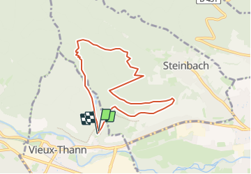

Length
7.5 km

Max alt
572 m

Uphill gradient
282 m
Km-Effort
11.3 km

Min alt
352 m

Downhill gradient
289 m
Boucle
Yes
Creation date :
2023-12-17 16:59:14.048
Updated on :
2023-12-17 17:03:45.268
2h34
Difficulty : Easy

FREE GPS app for hiking
 SityTrail
IGN / Geographical institutes
SityTrail Plus
The world is yours!
About
Trail On foot of 7.5 km to be discovered at Grand Est, Haut-Rhin, Vieux-Thann. This trail is proposed by philvor.
Positioning
Country:
France
Region :
Grand Est
Department/Province :
Haut-Rhin
Municipality :
Vieux-Thann
Location:
Unknown
Start:(Dec)
Start:(UTM)
360136 ; 5296893 (32T) N.
Comments