


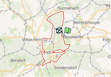
Autour de Ferrette

Alain28/01
User

Length
18.1 km

Max alt
648 m

Uphill gradient
621 m
Km-Effort
26 km

Min alt
377 m

Downhill gradient
630 m
Boucle
Yes
Creation date :
2023-12-18 09:38:59.605
Updated on :
2023-12-18 09:40:30.241
6h00
Difficulty : Medium

FREE GPS app for hiking
 SityTrail
IGN / Geographical institutes
SityTrail Plus
The world is yours!
About
Trail Walking of 18.1 km to be discovered at Grand Est, Haut-Rhin, Bouxwiller. This trail is proposed by Alain28/01.
Positioning
Country:
France
Region :
Grand Est
Department/Province :
Haut-Rhin
Municipality :
Bouxwiller
Location:
Unknown
Start:(Dec)
Start:(UTM)
374486 ; 5262686 (32T) N.
Comments