


Brie sous Chalais 24-02-2015

jmrobin
User
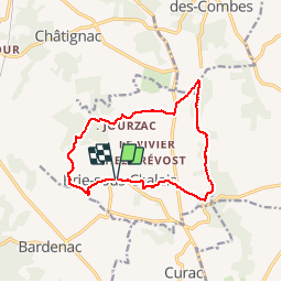

Length
13.5 km

Max alt
150 m

Uphill gradient
274 m
Km-Effort
17.2 km

Min alt
62 m

Downhill gradient
274 m
Boucle
Yes
Creation date :
2019-03-04 10:38:09.239
Updated on :
2019-03-04 10:38:09.268
2h57
Difficulty : Medium

FREE GPS app for hiking
 SityTrail
IGN / Geographical institutes
SityTrail Plus
The world is yours!
About
Trail Walking of 13.5 km to be discovered at New Aquitaine, Charente, Brie-sous-Chalais. This trail is proposed by jmrobin.
Description
Ok cheval
Positioning
Country:
France
Region :
New Aquitaine
Department/Province :
Charente
Municipality :
Brie-sous-Chalais
Location:
Unknown
Start:(Dec)
Start:(UTM)
265355 ; 5022310 (31T) N.
Comments