


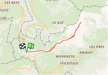
La route des Crêtes

cron
User


4h18
Difficulty : Medium

FREE GPS app for hiking
 SityTrail
IGN / Geographical institutes
SityTrail Plus
The world is yours!
About
Trail Walking of 13.2 km to be discovered at Auvergne-Rhône-Alpes, Savoy, Hauteluce. This trail is proposed by cron.
Description
Départ à côté de l'hôtel Le Calgary. Promenade avec une vue superbe sur les Aravis , le Beaufortain et le Mont-Blanc. Entièrement praticable à pied, sans raquettes, durant l'hiver car c'est un parcours piétons damé.
Positioning
Comments