


cuneige

michel calvo 2
User
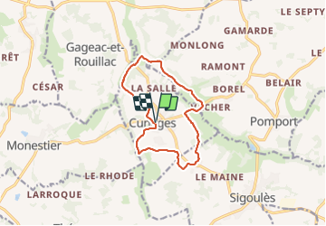

Length
11.7 km

Max alt
122 m

Uphill gradient
168 m
Km-Effort
13.9 km

Min alt
37 m

Downhill gradient
168 m
Boucle
Yes
Creation date :
2023-12-27 13:26:03.204
Updated on :
2023-12-27 16:08:14.176
2h40
Difficulty : Difficult

FREE GPS app for hiking
 SityTrail
IGN / Geographical institutes
SityTrail Plus
The world is yours!
About
Trail Walking of 11.7 km to be discovered at New Aquitaine, Dordogne, Cunèges. This trail is proposed by michel calvo 2.
Positioning
Country:
France
Region :
New Aquitaine
Department/Province :
Dordogne
Municipality :
Cunèges
Location:
Unknown
Start:(Dec)
Start:(UTM)
292174 ; 4961763 (31T) N.
Comments