


les Pérics depuis refuge Camporells

34christophe
User
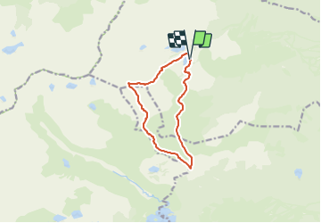

Length
11 km

Max alt
2676 m

Uphill gradient
621 m
Km-Effort
19.2 km

Min alt
2120 m

Downhill gradient
623 m
Boucle
Yes
Creation date :
2023-12-28 19:10:11.502
Updated on :
2023-12-29 10:09:30.408
4h22
Difficulty : Very difficult

FREE GPS app for hiking
 SityTrail
IGN / Geographical institutes
SityTrail Plus
The world is yours!
About
Trail Walking of 11 km to be discovered at Occitania, Pyrénées-Orientales, Formiguères. This trail is proposed by 34christophe.
Description
refuge, petit Péric, grand Péric, cabane la Balmeta, refuge
Positioning
Country:
France
Region :
Occitania
Department/Province :
Pyrénées-Orientales
Municipality :
Formiguères
Location:
Unknown
Start:(Dec)
Start:(UTM)
418932 ; 4719276 (31T) N.
Comments