Trail  Villers-sur-Auchy - Duo Penotti - Photo
© OpenStreetMap contributors
Length
Length
8.7 km
Max alt
Max alt
191 m
Uphill gradient
Uphill gradient
148 m
Km-Effort
Km-Effort  
10.6 km
Min alt
Min alt
109 m
Downhill gradient
Downhill gradient
148 m
Boucle
Boucle
Yes
Creation date :
2023-12-31 12:21:54.0
Updated on :
2023-12-31 14:31:23.83

(0 Reviews)


Scan this QR Code to open this trail in the SityTrail application

FREE GPS app for hiking

Logo SityTrail SityTrail

IGN / Geographical institutes

Download SityTrail from the App Store Download SityTrail from Google Play

Logo SityTrail SityTrail World

The world is yours!

Download SityTrail from the App Store Download SityTrail from Google Play Download SityTrail on Huawei AppGallery

About

Trail of 8.7 km to be discovered at Hauts-de-France, Oise, Villers-sur-Auchy. This trail is proposed by 001501.4323e38e4c0649c4b45ae5dd44cd3b61.1030.

Elevation profile

Positioning

Country:
France
Region :
Hauts-de-France
Department/Province :
Oise
Municipality :
Villers-sur-Auchy
Location:
Unknown
Start:(UTM)
412674 ; 5480837 (31U) N.

Trails nearby

Trail Walking Senantes - Senantes - Photo
Walking
jpblimond

Walking

Medium
Senantes, Hauts-de-France, Oise, France
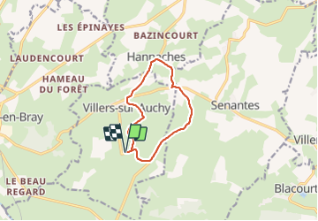
18.7 km | 23 km-effort
4h 47min
Yes
Trail Walking Villers-sur-Auchy - Villers-sur-Auchy  - Photo
Walking
jpblimond

Walking

Medium
Villers-sur-Auchy, Hauts-de-France, Oise, France
18.1 km | 22 km-effort
4h 11min
Yes
Trail Walking Saint-Pierre-es-Champs - Saint-Pierre-es-Champs - Les tourbières Bouchevilliers - Photo
Walking
marcel.F

Walking

Easy
Saint-Pierre-es-Champs, Hauts-de-France, Oise, France
14.6 km | 18.8 km-effort
4h 3min
Yes
Trail Walking Saint-Pierre-es-Champs - Saint-Pierre-es-Champs - Les tourbières - Photo
Walking
marcel.F

Walking

Easy
Saint-Pierre-es-Champs, Hauts-de-France, Oise, France
11.9 km | 15.1 km-effort
3h 16min
Yes
Trail Walking Senantes - Senantes - le chemin de la source - Photo
Walking
marcel.F

Walking

Easy
Senantes, Hauts-de-France, Oise, France
12.7 km | 15.2 km-effort
3h 19min
Yes
Trail Walking Saint-Germer-de-Fly - St-Germer-de-Fly - le sentier du lavoir - Photo
Walking
marcel.F

Walking

Easy
(1)
Saint-Germer-de-Fly, Hauts-de-France, Oise, France
11.8 km | 14.3 km-effort
3h 7min
Yes
Trail Walking Saint-Pierre-es-Champs - St-Pierre-es-Champs - Côte Ste Hélène - Photo
Walking
marcel.F

Walking

Medium
(1)
Saint-Pierre-es-Champs, Hauts-de-France, Oise, France
7.7 km | 9.8 km-effort
2h 7min
Yes
Trail Electric bike Saint-Germer-de-Fly - saint germer de fly  - Photo
Electric bike
rgo76

Electric bike

Medium
Saint-Germer-de-Fly, Hauts-de-France, Oise, France
32 km | 39 km-effort
2h 47min
Yes
Trail 4x4 Blacourt - RETOUR DU 7 MAI - Photo
4x4
club de la bresle

4x4

Very easy
Blacourt, Hauts-de-France, Oise, France
43 km | 50 km-effort
Unknown
No


Close
My subscriptions