Trail Walking Senantes - Senantes - Photo
© OpenStreetMap contributors
Length
Length
18.7 km
Max alt
Max alt
207 m
Uphill gradient
Uphill gradient
296 m
Km-Effort
Km-Effort  
23 km
Min alt
Min alt
111 m
Downhill gradient
Downhill gradient
294 m
Boucle
Boucle
Yes
Creation date :
2019-04-22 11:05:30.472
Updated on :
2019-04-27 16:49:30.489

(0 Reviews)

Walking
Walking
4h47
Difficulty : Medium

Scan this QR Code to open this trail in the SityTrail application

FREE GPS app for hiking

Logo SityTrail SityTrail

IGN / Geographical institutes

Download SityTrail from the App Store Download SityTrail from Google Play

Logo SityTrail SityTrail World

The world is yours!

Download SityTrail from the App Store Download SityTrail from Google Play Download SityTrail on Huawei AppGallery

About

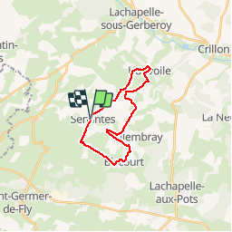
Trail Walking of 18.7 km to be discovered at Hauts-de-France, Oise, Senantes. This trail is proposed by jpblimond.

Description

Entre le KM 6,9 et le Km 7,3 le terrain est impraticable

Elevation profile

Photos

Positioning

Country:
France
Region :
Hauts-de-France
Department/Province :
Oise
Municipality :
Senantes
Location:
Unknown
Start:(UTM)
415715 ; 5482165 (31U) N.

Trails nearby

Trail Mountain bike Lachapelle-aux-Pots - ACTIVE LOG 003 - Photo
Mountain bike
sebcar

Mountain bike

Medium
(1)
Lachapelle-aux-Pots, Hauts-de-France, Oise, France
19.1 km | 24 km-effort
1h 39min
Yes
Trail Walking Hanvoile - 20200903-Gerberoy - Photo
Walking
doudet

Walking

Medium
Hanvoile, Hauts-de-France, Oise, France
24 km | 29 km-effort
6h 59min
Yes
Trail On foot Gerberoy - gerberoy - Photo
On foot
nicole.reine@wanadoo.fr

On foot

Easy
Gerberoy, Hauts-de-France, Oise, France
6.3 km | 8 km-effort
1h 49min
Yes
Trail Walking Villers-sur-Auchy - Villers-sur-Auchy  - Photo
Walking
jpblimond

Walking

Medium
Villers-sur-Auchy, Hauts-de-France, Oise, France
18.1 km | 22 km-effort
4h 11min
Yes
Trail Walking Lachapelle-aux-Pots - Lachapelle-aux-pots - Héricourt - La Frénoye - Armentières - Photo
Walking
Marie-Claire-mcp

Walking

Difficult
Lachapelle-aux-Pots, Hauts-de-France, Oise, France
10.7 km | 13.7 km-effort
3h 6min
Yes
Trail Walking Lachapelle-aux-Pots - Lachapelle aux pots - Armentières 11 km - Photo
Walking
Marie-Claire-mcp

Walking

Difficult
Lachapelle-aux-Pots, Hauts-de-France, Oise, France
10.6 km | 13.5 km-effort
3h 4min
Yes
Trail Walking Lachapelle-aux-Pots - Lachapelle aux Pots - Rando santé 1 - Photo
Walking
marcel.F

Walking

Medium
Lachapelle-aux-Pots, Hauts-de-France, Oise, France
5.6 km | 6.4 km-effort
1h 24min
Yes
Trail Walking Lachapelle-aux-Pots - Lachapelle-aux-Pots - autour de la Crapaudière vers 2 - Photo
Walking
marcel.F

Walking

Easy
Lachapelle-aux-Pots, Hauts-de-France, Oise, France
9.9 km | 11.5 km-effort
2h 32min
Yes
Trail Walking Lachapelle-aux-Pots - Lachapelle-aux-Pots - autour de la Crapaudière - Photo
Walking
marcel.F

Walking

Easy
Lachapelle-aux-Pots, Hauts-de-France, Oise, France
9.4 km | 10.9 km-effort
2h 25min
Yes


Close
My subscriptions