


Parking à 200m de la salle des fêtes de Bourbach le Bas - Heidenfeld - Hasenwald - Saegenkopf et retour par l'ancienne mine et Chapelle des Mineurs

patrickbeyrath
User
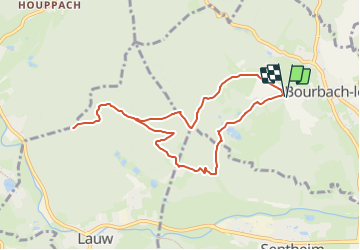

Length
8.4 km

Max alt
534 m

Uphill gradient
215 m
Km-Effort
11.3 km

Min alt
383 m

Downhill gradient
217 m
Boucle
Yes
Creation date :
2024-01-05 07:03:28.874
Updated on :
2024-01-05 07:18:21.144
2h33
Difficulty : Medium

FREE GPS app for hiking
 SityTrail
IGN / Geographical institutes
SityTrail Plus
The world is yours!
About
Trail Walking of 8.4 km to be discovered at Grand Est, Haut-Rhin, Bourbach-le-Bas. This trail is proposed by patrickbeyrath.
Positioning
Country:
France
Region :
Grand Est
Department/Province :
Haut-Rhin
Municipality :
Bourbach-le-Bas
Location:
Unknown
Start:(Dec)
Start:(UTM)
354074 ; 5292878 (32T) N.
Comments