


Rs gerStade 2024 15 p

LouisROGER
User GUIDE
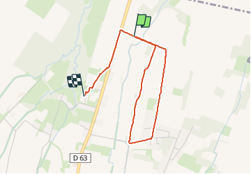

Length
3.8 km

Max alt
396 m

Uphill gradient
30 m
Km-Effort
4.1 km

Min alt
380 m

Downhill gradient
21 m
Boucle
No
Creation date :
2024-01-10 12:59:15.515
Updated on :
2024-01-10 14:14:38.953
1h15
Difficulty : Easy

FREE GPS app for hiking
 SityTrail
IGN / Geographical institutes
SityTrail Plus
The world is yours!
About
Trail Walking of 3.8 km to be discovered at New Aquitaine, Pyrénées-Atlantiques, Ger. This trail is proposed by LouisROGER.
Positioning
Country:
France
Region :
New Aquitaine
Department/Province :
Pyrénées-Atlantiques
Municipality :
Ger
Location:
Unknown
Start:(Dec)
Start:(UTM)
740041 ; 4795971 (30T) N.
Comments