


Trace M2 Galette Menhir Guy

mitch1952
User
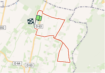

Length
8.3 km

Max alt
402 m

Uphill gradient
73 m
Km-Effort
9.3 km

Min alt
378 m

Downhill gradient
69 m
Boucle
Yes
Creation date :
2024-01-10 12:46:09.0
Updated on :
2024-01-10 14:53:46.487

FREE GPS app for hiking
 SityTrail
IGN / Geographical institutes
SityTrail Plus
The world is yours!
About
Trail of 8.3 km to be discovered at New Aquitaine, Pyrénées-Atlantiques, Ger. This trail is proposed by mitch1952.
Positioning
Country:
France
Region :
New Aquitaine
Department/Province :
Pyrénées-Atlantiques
Municipality :
Ger
Location:
Unknown
Start:(Dec)
Start:(UTM)
739554 ; 4795471 (30T) N.
Comments