


saint Sulpice d'arnoult

taguette
User
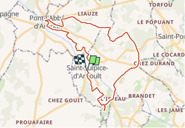

Length
19.8 km

Max alt
42 m

Uphill gradient
138 m
Km-Effort
22 km

Min alt
10 m

Downhill gradient
144 m
Boucle
Yes
Creation date :
2024-01-16 07:38:05.647
Updated on :
2024-01-16 11:47:26.93
4h07
Difficulty : Medium

FREE GPS app for hiking
 SityTrail
IGN / Geographical institutes
SityTrail Plus
The world is yours!
About
Trail Walking of 19.8 km to be discovered at New Aquitaine, Charente-Maritime, Saint-Sulpice-d'Arnoult. This trail is proposed by taguette.
Positioning
Country:
France
Region :
New Aquitaine
Department/Province :
Charente-Maritime
Municipality :
Saint-Sulpice-d'Arnoult
Location:
Unknown
Start:(Dec)
Start:(UTM)
667241 ; 5074597 (30T) N.
Comments