


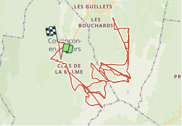
Piste Corrençon

GOHIER
User

Length
52 km

Max alt
2056 m

Uphill gradient
4899 m
Km-Effort
117 km

Min alt
1098 m

Downhill gradient
4967 m
Boucle
No
Creation date :
2024-01-16 09:45:53.0
Updated on :
2024-01-16 14:12:40.9
4h21
Difficulty : Unknown

FREE GPS app for hiking
 SityTrail
IGN / Geographical institutes
SityTrail Plus
The world is yours!
About
Trail Alpine skiing of 52 km to be discovered at Auvergne-Rhône-Alpes, Isère, Corrençon-en-Vercors. This trail is proposed by GOHIER.
Description
Sous la pluie
Positioning
Country:
France
Region :
Auvergne-Rhône-Alpes
Department/Province :
Isère
Municipality :
Corrençon-en-Vercors
Location:
Unknown
Start:(Dec)
Start:(UTM)
698893 ; 4988769 (31T) N.
Comments