


trace

vaillantjm
User
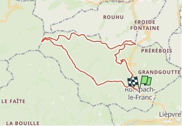

Length
17.4 km

Max alt
780 m

Uphill gradient
678 m
Km-Effort
26 km

Min alt
302 m

Downhill gradient
677 m
Boucle
Yes
Creation date :
2024-01-17 17:07:16.916
Updated on :
2024-04-09 12:08:23.459
6h00
Difficulty : Difficult

FREE GPS app for hiking
 SityTrail
IGN / Geographical institutes
SityTrail Plus
The world is yours!
About
Trail Walking of 17.4 km to be discovered at Grand Est, Haut-Rhin, Rombach-le-Franc. This trail is proposed by vaillantjm.
Description
La partie entre le col de Fouchy et le col de Noirceux est magnifique mais il faut faire avec 7 km de route asphaltée à la sortie et à l'entrée de Rombach. A vous de choisir!
Positioning
Country:
France
Region :
Grand Est
Department/Province :
Haut-Rhin
Municipality :
Rombach-le-Franc
Location:
Unknown
Start:(Dec)
Start:(UTM)
371082 ; 5349237 (32U) N.
Comments