


Lanslevillard en boucle par le col de la madeleine

chasle
User
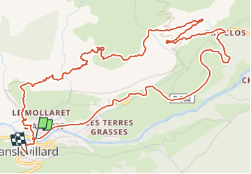

Length
8.4 km

Max alt
1863 m

Uphill gradient
432 m
Km-Effort
14.1 km

Min alt
1460 m

Downhill gradient
406 m
Boucle
Yes
Creation date :
2024-01-18 14:35:55.605
Updated on :
2024-01-19 17:39:31.506
3h12
Difficulty : Difficult

FREE GPS app for hiking
 SityTrail
IGN / Geographical institutes
SityTrail Plus
The world is yours!
About
Trail Walking of 8.4 km to be discovered at Auvergne-Rhône-Alpes, Savoy, Val-Cenis. This trail is proposed by chasle.
Positioning
Country:
France
Region :
Auvergne-Rhône-Alpes
Department/Province :
Savoy
Municipality :
Val-Cenis
Location:
Lanslevillard
Start:(Dec)
Start:(UTM)
336333 ; 5017311 (32T) N.
Comments