Trail Walking Dommartemont - Dommartemont (Plateau de Malzéville et Amezule) 15 050m +350m - Photo

Dommartemont (Plateau de Malzéville et Amezule) 15 050m +350m

© OpenStreetMap contributors
Length
Length
15 km
Max alt
Max alt
371 m
Uphill gradient
Uphill gradient
350 m
Km-Effort
Km-Effort  
19.7 km
Min alt
Min alt
193 m
Downhill gradient
Downhill gradient
351 m
Boucle
Boucle
Yes
Creation date :
2024-01-23 08:00:32.119
Updated on :
2024-01-23 15:10:59.88

(0 Reviews)

Walking
Walking
3h50
Difficulty : Medium

Scan this QR Code to open this trail in the SityTrail application

FREE GPS app for hiking

Logo SityTrail SityTrail

IGN / Geographical institutes

Download SityTrail from the App Store Download SityTrail from Google Play

Logo SityTrail SityTrail World

The world is yours!

Download SityTrail from the App Store Download SityTrail from Google Play Download SityTrail on Huawei AppGallery

About

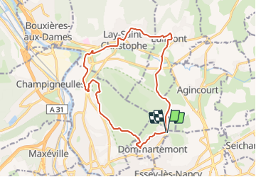
Trail Walking of 15 km to be discovered at Grand Est, Meurthe-et-Moselle, Dommartemont. This trail is proposed by DanielROLLET.

Description

2024 01 23 - 9h00 à 12h50 - avec Marie
Temps couvert et calme
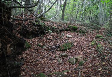
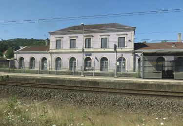
Départ/retour resto ferme Ste Geneviève > Eulmont > Lay-St-Christophe > Champigneulles.
Belle découverte de la Basse-Lay et de Lay-saint-Christophe.

Elevation profile

Positioning

Country:
France
Region :
Grand Est
Department/Province :
Meurthe-et-Moselle
Municipality :
Dommartemont
Location:
Unknown
Start:(UTM)
295642 ; 5399893 (32U) N.

Trails nearby

Trail Running Pulnoy - Parcours de santé PULNOY - Photo
Running
DENOMME

Running

Very easy
(1)
Pulnoy, Grand Est, Meurthe-et-Moselle, France
4.8 km | 6 km-effort
58min
Yes
Trail On foot Champigneulles - Circuit du Val Saint-Barthélémy - Photo
On foot
PRO

On foot

Easy
Champigneulles, Grand Est, Meurthe-et-Moselle, France
7 km | 8.6 km-effort
1h 57min
Yes
Trail On foot Agincourt - Circuit M - Photo
On foot
PRO

On foot

Easy
Agincourt, Grand Est, Meurthe-et-Moselle, France
13.3 km | 17.8 km-effort
4h 3min
No
Trail Walking Nancy - Ma dernière avant opération  - Photo
Walking
Toyot 8

Walking

Very difficult
(1)
Nancy, Grand Est, Meurthe-et-Moselle, France
22 km | 25 km-effort
4h 12min
Yes
Trail Walking Nancy - Ma rando du jour - Photo
Walking
Toyot 8

Walking

Difficult
Nancy, Grand Est, Meurthe-et-Moselle, France
35 km | 41 km-effort
5h 55min
Yes
Trail Walking Nancy - Nancy Gondreville Nancy - Photo
Walking
Toyot 8

Walking

Difficult
Nancy, Grand Est, Meurthe-et-Moselle, France
64 km | 74 km-effort
10h 57min
Yes
Trail Walking Nancy - Nancy Saizeray Jaillon Pierre la Treiche Marion Nancy  - Photo
Walking
Toyot 8

Walking

Difficult
Nancy, Grand Est, Meurthe-et-Moselle, France
73 km | 85 km-effort
12h 13min
Yes
Trail On foot Champigneulles - Circuit du Vallum de la Fourasse - Photo
On foot
PRO

On foot

Easy
Champigneulles, Grand Est, Meurthe-et-Moselle, France
3.3 km | 4.9 km-effort
1h 6min
Yes
Trail On foot Bouxières-aux-Dames - Circuit moyenne ceinture - Photo
On foot
PRO

On foot

Easy
Bouxières-aux-Dames, Grand Est, Meurthe-et-Moselle, France
3.8 km | 5.3 km-effort
1h 12min
Yes


Close
My subscriptions