


la roche à Thomas

melsacri
User
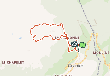

Length
8.8 km

Max alt
2323 m

Uphill gradient
932 m
Km-Effort
21 km

Min alt
1376 m

Downhill gradient
942 m
Boucle
Yes
Creation date :
2024-01-26 08:12:57.435
Updated on :
2024-01-26 12:07:54.808
3h54
Difficulty : Medium

FREE GPS app for hiking
 SityTrail
IGN / Geographical institutes
SityTrail Plus
The world is yours!
About
Trail Touring skiing of 8.8 km to be discovered at Auvergne-Rhône-Alpes, Savoy, Aime-la-Plagne. This trail is proposed by melsacri.
Positioning
Country:
France
Region :
Auvergne-Rhône-Alpes
Department/Province :
Savoy
Municipality :
Aime-la-Plagne
Location:
Granier
Start:(Dec)
Start:(UTM)
316827 ; 5049853 (32T) N.
Comments