


2024 01 27 Descente du Galtz

staubalex
User
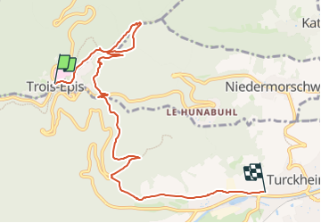

Length
8.6 km

Max alt
720 m

Uphill gradient
84 m
Km-Effort
11.1 km

Min alt
239 m

Downhill gradient
502 m
Boucle
No
Creation date :
2024-01-27 07:42:02.69
Updated on :
2024-01-27 07:43:20.414
2h00
Difficulty : Easy

FREE GPS app for hiking
 SityTrail
IGN / Geographical institutes
SityTrail Plus
The world is yours!
About
Trail Other activity of 8.6 km to be discovered at Grand Est, Haut-Rhin, Ammerschwihr. This trail is proposed by staubalex.
Positioning
Country:
France
Region :
Grand Est
Department/Province :
Haut-Rhin
Municipality :
Ammerschwihr
Location:
Unknown
Start:(Dec)
Start:(UTM)
368303 ; 5328942 (32U) N.
Comments