Trail Walking Valcebollère - Chemin de la Retirada - Photo
© OpenStreetMap contributors
Length
Length
11.3 km
Max alt
Max alt
2206 m
Uphill gradient
Uphill gradient
730 m
Km-Effort
Km-Effort  
21 km
Min alt
Min alt
1517 m
Downhill gradient
Downhill gradient
732 m
Boucle
Boucle
Yes
Creation date :
2024-01-27 17:46:44.296
Updated on :
2024-01-27 17:56:51.095

(0 Reviews)

Walking
Walking
4h47
Difficulty : Very difficult

Scan this QR Code to open this trail in the SityTrail application

FREE GPS app for hiking

Logo SityTrail SityTrail

IGN / Geographical institutes

Download SityTrail from the App Store Download SityTrail from Google Play

Logo SityTrail SityTrail World

The world is yours!

Download SityTrail from the App Store Download SityTrail from Google Play Download SityTrail on Huawei AppGallery

About

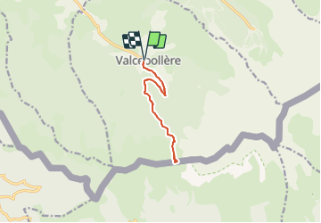
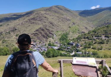
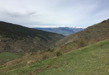
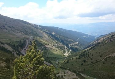
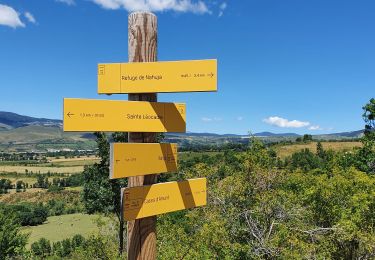
Trail Walking of 11.3 km to be discovered at Occitania, Pyrénées-Orientales, Valcebollère. This trail is proposed by rene091957.

Description

Rando n° 26 sur le panneau situé à l'entrée du parking du village. Suivre le balisage en jaune jusqu'à la piste après le ruisseau. A la fin de la piste, prendre le sentier qui monte à gauche jusqu'à la forêt puis monter jusqu'à la frontière (Borne 505).Retour par le chemin inverse.

Elevation profile

Positioning

Country:
France
Region :
Occitania
Department/Province :
Pyrénées-Orientales
Municipality :
Valcebollère
Location:
Unknown
Start:(UTM)
420571 ; 4693164 (31T) N.

Trails nearby

Trail Walking Nahuja - boucle de Nahuja - Photo
Walking
crijack

Walking

Medium
(1)
Nahuja, Occitania, Pyrénées-Orientales, France
11.8 km | 18.2 km-effort
2h 44min
Yes
Trail Walking Valcebollère - Chapelle San Bernabéu  - Photo
Walking
lolyhalle

Walking

Easy
Valcebollère, Occitania, Pyrénées-Orientales, France
5.4 km | 8.6 km-effort
1h 50min
No
Trail Walking Valcebollère - la cami de sant bertheleu - Photo
Walking
Merlos

Walking

Very easy
Valcebollère, Occitania, Pyrénées-Orientales, France
6.2 km | 9.7 km-effort
2h 25min
Yes
Trail Walking Valcebollère - Valcebollère chapelle Saint Barnabeu - Photo
Walking
crijack

Walking

Medium
Valcebollère, Occitania, Pyrénées-Orientales, France
11.3 km | 17.4 km-effort
3h 27min
Yes
Trail Walking Valcebollère - Valcebollère chapelle Saint Barnabeu - Photo
Walking
crijack

Walking

Medium
Valcebollère, Occitania, Pyrénées-Orientales, France
11.3 km | 17.4 km-effort
3h 27min
Yes
Trail Walking Err - Pigmal - Photo
Walking
ip45

Walking

Very difficult
Err, Occitania, Pyrénées-Orientales, France
13.2 km | 27 km-effort
7h 8min
Yes
Trail Snowshoes Err - Pas de Lladres - Err - Photo
Snowshoes
tracegps

Snowshoes

Difficult
Err, Occitania, Pyrénées-Orientales, France
15.1 km | 28 km-effort
5h 0min
Yes
Trail Walking Err - Puig Puigmal d'err - Photo
Walking
Michel_Martin

Walking

Medium
Err, Occitania, Pyrénées-Orientales, France
10.4 km | 23 km-effort
3h 12min
Yes
Trail Walking Nahuja - Nahuja refuge - Photo
Walking
marchev

Walking

Medium
Nahuja, Occitania, Pyrénées-Orientales, France
9.4 km | 14.8 km-effort
3h 54min
Yes


Close
My subscriptions