


Barker Dronne Via Bourdeilles

pierre67000
User
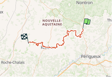

Length
96 km

Max alt
226 m

Uphill gradient
1867 m
Km-Effort
121 km

Min alt
43 m

Downhill gradient
1885 m
Boucle
No
Creation date :
2024-01-28 16:59:38.808
Updated on :
2024-01-28 17:00:33.868
27h29
Difficulty : Very difficult

FREE GPS app for hiking
 SityTrail
IGN / Geographical institutes
SityTrail Plus
The world is yours!
About
Trail On foot of 96 km to be discovered at New Aquitaine, Dordogne, Brantôme en Périgord. This trail is proposed by pierre67000.
Positioning
Country:
France
Region :
New Aquitaine
Department/Province :
Dordogne
Municipality :
Brantôme en Périgord
Location:
Unknown
Start:(Dec)
Start:(UTM)
315824 ; 5026215 (31T) N.
Comments