


de Molitg à St Jaume

FAUCET
User
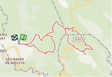

Length
12.9 km

Max alt
815 m

Uphill gradient
600 m
Km-Effort
21 km

Min alt
527 m

Downhill gradient
602 m
Boucle
Yes
Creation date :
2024-01-30 12:41:05.359
Updated on :
2024-01-30 12:41:06.97
4h44
Difficulty : Very difficult

FREE GPS app for hiking
 SityTrail
IGN / Geographical institutes
SityTrail Plus
The world is yours!
About
Trail Walking of 12.9 km to be discovered at Occitania, Pyrénées-Orientales, Molitg-les-Bains. This trail is proposed by FAUCET.
Positioning
Country:
France
Region :
Occitania
Department/Province :
Pyrénées-Orientales
Municipality :
Molitg-les-Bains
Location:
Unknown
Start:(Dec)
Start:(UTM)
450003 ; 4722492 (31T) N.
Comments