


Montgenevre

GOHIER
User
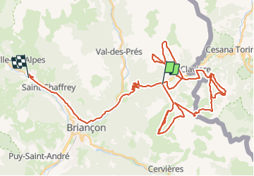

Length
64 km

Max alt
2578 m

Uphill gradient
4270 m
Km-Effort
123 km

Min alt
1322 m

Downhill gradient
4744 m
Boucle
No
Creation date :
2024-01-30 10:01:57.0
Updated on :
2024-01-31 09:23:00.331
6h10
Difficulty : Unknown

FREE GPS app for hiking
 SityTrail
IGN / Geographical institutes
SityTrail Plus
The world is yours!
About
Trail Alpine skiing of 64 km to be discovered at Provence-Alpes-Côte d'Azur, Hautes-Alpes, Montgenèvre. This trail is proposed by GOHIER.
Description
Piste
Positioning
Country:
France
Region :
Provence-Alpes-Côte d'Azur
Department/Province :
Hautes-Alpes
Municipality :
Montgenèvre
Location:
Unknown
Start:(Dec)
Start:(UTM)
319907 ; 4977550 (32T) N.
Comments