


Croustille vagabonds

papajp
User

Length
6.7 km

Max alt
244 m

Uphill gradient
39 m
Km-Effort
7.2 km

Min alt
230 m

Downhill gradient
39 m
Boucle
Yes
Creation date :
2024-01-31 09:35:56.0
Updated on :
2024-01-31 11:24:38.77

FREE GPS app for hiking
 SityTrail
IGN / Geographical institutes
SityTrail Plus
The world is yours!
About
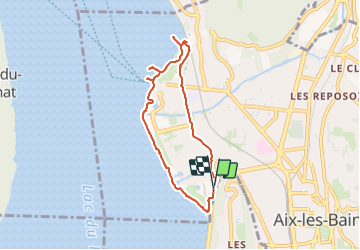
Trail of 6.7 km to be discovered at Auvergne-Rhône-Alpes, Savoy, Aix-les-Bains. This trail is proposed by papajp.
Photos


Positioning
Country:
France
Region :
Auvergne-Rhône-Alpes
Department/Province :
Savoy
Municipality :
Aix-les-Bains
Location:
Unknown
Start:(Dec)
Start:(UTM)
725494 ; 5063907 (31T) N.
Comments