


Vauvenargues 1er février 2024

rlebasque
User
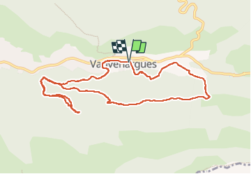

Length
11.2 km

Max alt
540 m

Uphill gradient
313 m
Km-Effort
15.4 km

Min alt
359 m

Downhill gradient
312 m
Boucle
Yes
Creation date :
2024-02-01 07:55:38.936
Updated on :
2024-02-01 13:18:40.069
5h22
Difficulty : Difficult

FREE GPS app for hiking
 SityTrail
IGN / Geographical institutes
SityTrail Plus
The world is yours!
About
Trail Walking of 11.2 km to be discovered at Provence-Alpes-Côte d'Azur, Bouches-du-Rhône, Vauvenargues. This trail is proposed by rlebasque.
Positioning
Country:
France
Region :
Provence-Alpes-Côte d'Azur
Department/Province :
Bouches-du-Rhône
Municipality :
Vauvenargues
Location:
Unknown
Start:(Dec)
Start:(UTM)
710462 ; 4825762 (31T) N.
Comments