Trail Walking Lacapelle-Barrès - puy de Bane - Photo
© OpenStreetMap contributors
Length
Length
19.2 km
Max alt
Max alt
1467 m
Uphill gradient
Uphill gradient
510 m
Km-Effort
Km-Effort  
26 km
Min alt
Min alt
981 m
Downhill gradient
Downhill gradient
507 m
Boucle
Boucle
Yes
Creation date :
2024-02-01 08:47:51.35
Updated on :
2024-02-01 13:45:43.956

(0 Reviews)

Walking
Walking
4h03
Difficulty : Difficult

Scan this QR Code to open this trail in the SityTrail application

FREE GPS app for hiking

Logo SityTrail SityTrail

IGN / Geographical institutes

Download SityTrail from the App Store Download SityTrail from Google Play

Logo SityTrail SityTrail World

The world is yours!

Download SityTrail from the App Store Download SityTrail from Google Play Download SityTrail on Huawei AppGallery

About

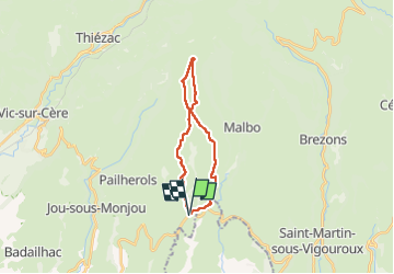
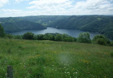
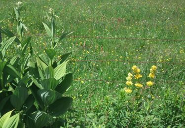
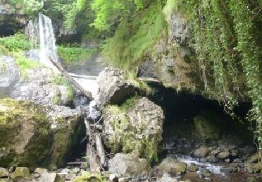
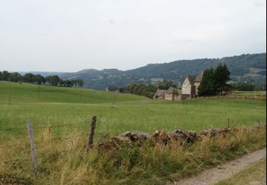
Trail Walking of 19.2 km to be discovered at Auvergne-Rhône-Alpes, Cantal, Lacapelle-Barrès. This trail is proposed by Jean-Marie Bousquet.

Description

boucle au départ de Lacapelle Barres

Elevation profile

Positioning

Country:
France
Region :
Auvergne-Rhône-Alpes
Department/Province :
Cantal
Municipality :
Lacapelle-Barrès
Location:
Unknown
Start:(UTM)
478157 ; 4975772 (31T) N.

Trails nearby

Trail Walking Thérondels - Thérondels,Nigresserre - Photo
Walking
paul12

Walking

Easy
(1)
Thérondels, Occitania, Aveyron, France
12.7 km | 14.8 km-effort
3h 14min
No
Trail Walking Pailherols - Pailherols chapelle du Cantal  - Photo
Walking
GUIDE
antignacs

Walking

Medium
Pailherols, Auvergne-Rhône-Alpes, Cantal, France
21 km | 29 km-effort
5h 29min
Yes
Trail Walking Pailherols - rando sentier des  gentianes - Photo
Walking
Sandrine 15

Walking

Medium
Pailherols, Auvergne-Rhône-Alpes, Cantal, France
13.1 km | 17.7 km-effort
3h 20min
Yes
Trail Walking Jou-sous-Monjou - Cantal - Jou sous Monjou - 7.7km 300m 2h40 - 2019 06 27 - Photo
Walking
Orcal37

Walking

Easy
Jou-sous-Monjou, Auvergne-Rhône-Alpes, Cantal, France
7.7 km | 11.7 km-effort
2h 40min
Yes
Trail Walking Thérondels - Balade à la presqu''ile de Laussac - Thérondels - Photo
Walking
tracegps

Walking

Difficult
(1)
Thérondels, Occitania, Aveyron, France
17.1 km | 24 km-effort
6h 0min
Yes
Trail Walking Pailherols - Du refuge des Fraux au Plomb du Cantal - Photo
Walking
tracegps

Walking

Difficult
Pailherols, Auvergne-Rhône-Alpes, Cantal, France
22 km | 32 km-effort
7h 0min
Yes
Trail Walking Pailherols - Le sentier des gentianes - Pailherols - Photo
Walking
tracegps

Walking

Medium
Pailherols, Auvergne-Rhône-Alpes, Cantal, France
13.7 km | 18.4 km-effort
3h 30min
Yes
Trail Mountain bike Malbo - VTT Malbo N10 - Photo
Mountain bike
macleon

Mountain bike

Medium
Malbo, Auvergne-Rhône-Alpes, Cantal, France
22 km | 28 km-effort
1h 51min
Yes
Trail Walking Pailherols - Vallée de Monjou.  - Photo
Walking
th.feur

Walking

Very easy
(1)
Pailherols, Auvergne-Rhône-Alpes, Cantal, France
15.5 km | 21 km-effort
5h 32min
Yes


Close
My subscriptions