Trail Walking Thérondels - Thérondels,Nigresserre - Photo

Thérondels,Nigresserre

 paul12
paul12

User

© OpenStreetMap contributors
Length
Length
12.7 km
Max alt
Max alt
956 m
Uphill gradient
Uphill gradient
152 m
Km-Effort
Km-Effort  
14.8 km
Min alt
Min alt
883 m
Downhill gradient
Downhill gradient
176 m
Boucle
Boucle
No
Creation date :
2018-04-01 00:00:00.0
Updated on :
2018-04-01 00:00:00.0

(1 Reviews)

Walking
Walking
3h14
Difficulty : Easy

Scan this QR Code to open this trail in the SityTrail application

FREE GPS app for hiking

Logo SityTrail SityTrail

IGN / Geographical institutes

Download SityTrail from the App Store Download SityTrail from Google Play

Logo SityTrail SityTrail World

The world is yours!

Download SityTrail from the App Store Download SityTrail from Google Play Download SityTrail on Huawei AppGallery

About

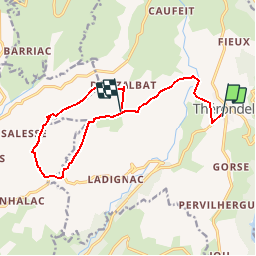
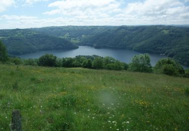
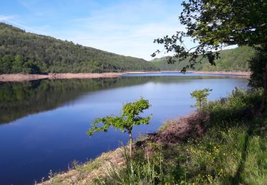
Trail Walking of 12.7 km to be discovered at Occitania, Aveyron, Thérondels. This trail is proposed by paul12.

Description

départ de thérondels vers la passerelle du Siniq, Frons, Terrain ULM, Nigresserre,Maisonneuve,Doux Albats

Elevation profile

Positioning

Country:
France
Region :
Occitania
Department/Province :
Aveyron
Municipality :
Thérondels
Location:
Unknown
Start:(UTM)
480785 ; 4971245 (31T) N.

Comments

Please log in to post a review or rate the element


À partir de Therondels


Trails nearby

Trail Walking Thérondels - Balade à la presqu''ile de Laussac - Thérondels - Photo
Walking
tracegps

Walking

Difficult
(1)
Thérondels, Occitania, Aveyron, France
17.1 km | 24 km-effort
6h 0min
Yes
Trail Walking Lacapelle-Barrès - puy de Bane - Photo
Walking
Jean-Marie Bousquet

Walking

Difficult
Lacapelle-Barrès, Auvergne-Rhône-Alpes, Cantal, France
19.2 km | 26 km-effort
4h 3min
Yes
Trail Walking Thérondels - Therondels  - Photo
Walking
bougnaou

Walking

Medium
Thérondels, Occitania, Aveyron, France
15.9 km | 22 km-effort
3h 14min
Yes
Trail Other activity Thérondels - Therondels à Pierrefort - Photo
Other activity
paul12

Other activity

Medium
Thérondels, Occitania, Aveyron, France
12.3 km | 17.6 km-effort
4h 21min
No
Trail Walking Paulhenc - tersons 13b - Photo
Walking
catherineslater

Walking

Very easy
Paulhenc, Auvergne-Rhône-Alpes, Cantal, France
11.4 km | 13.7 km-effort
3h 9min
No
Trail Walking Thérondels - THÉRONDELS _ et le paysan créa la prairie 2) - Photo
Walking
Elbe

Walking

Very easy
(1)
Thérondels, Occitania, Aveyron, France
4.1 km | 4.8 km-effort
1h 30min
Yes
Trail Walking Thérondels - Sentier imaginaire court Therondels  - Photo
Walking
Danielfontange

Walking

Easy
Thérondels, Occitania, Aveyron, France
3.6 km | 3.9 km-effort
1h 11min
Yes
Trail Walking Cantoin - Vines les berges du lac de Sarrans - Photo
Walking
les joyeux randonneurs

Walking

Difficult
Cantoin, Occitania, Aveyron, France
11.2 km | 16.4 km-effort
3h 43min
Yes
Trail Electric bike Saint-Martin-sous-Vigouroux - 6_280423 - Photo
Electric bike
ricou1964

Electric bike

Difficult
Saint-Martin-sous-Vigouroux, Auvergne-Rhône-Alpes, Cantal, France
71 km | 90 km-effort
10h 6min
No


Close
My subscriptions