Trail Walking Venelles - Le Puits de Fouquet - Meyrargues - L'Ameynaud - Photo

Le Puits de Fouquet - Meyrargues - L'Ameynaud

 Berpav
Berpav

User

© OpenStreetMap contributors
Length
Length
13.2 km
Max alt
Max alt
414 m
Uphill gradient
Uphill gradient
228 m
Km-Effort
Km-Effort  
16.2 km
Min alt
Min alt
237 m
Downhill gradient
Downhill gradient
228 m
Boucle
Boucle
Yes
Creation date :
2024-02-01 14:15:24.771
Updated on :
2024-02-01 14:16:26.38

(0 Reviews)

Walking
Walking
3h40
Difficulty : Difficult

Scan this QR Code to open this trail in the SityTrail application

FREE GPS app for hiking

Logo SityTrail SityTrail

IGN / Geographical institutes

Download SityTrail from the App Store Download SityTrail from Google Play

Logo SityTrail SityTrail World

The world is yours!

Download SityTrail from the App Store Download SityTrail from Google Play Download SityTrail on Huawei AppGallery

About

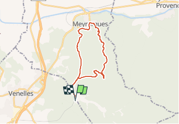
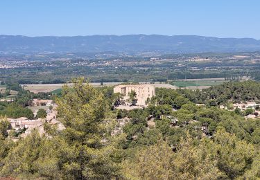
Trail Walking of 13.2 km to be discovered at Provence-Alpes-Côte d'Azur, Bouches-du-Rhône, Venelles. This trail is proposed by Berpav.

Description

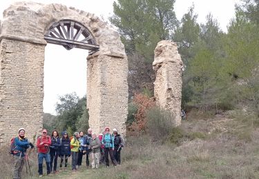
Une boucle sympathique en pleine campagne provençale permettant de découvrir les abords champêtre et le centre ville de Meyrargues. A l'aller après 1km500 bifurquer sur la droite vers un sentier montant menant jusqu'à Meyrargues. Le retour se réalise en bordure d'une voie ferrée, vous la longerez sur sentier tracé pour vous repérer.

Elevation profile

Positioning

Country:
France
Region :
Provence-Alpes-Côte d'Azur
Department/Province :
Bouches-du-Rhône
Municipality :
Venelles
Location:
Unknown
Start:(UTM)
703282 ; 4830166 (31T) N.

Trails nearby

Trail Walking Vauvenargues - Le Signal, Montagne Sainte-Victoire - Photo
Walking
tracegps

Walking

Medium
(2)
Vauvenargues, Provence-Alpes-Côte d'Azur, Bouches-du-Rhône, France
15 km | 25 km-effort
6h 19min
Yes
Trail On foot Vauvenargues - Sentier des Venturiers - Photo
On foot
PRO

On foot

Easy
Vauvenargues, Provence-Alpes-Côte d'Azur, Bouches-du-Rhône, France
5 km | 10.5 km-effort
2h 23min
No
Trail Mountain bike Venelles - Venelles version tête du Marquis - Photo
Mountain bike
samifly51

Mountain bike

Medium
(1)
Venelles, Provence-Alpes-Côte d'Azur, Bouches-du-Rhône, France
25 km | 33 km-effort
3h 58min
Yes
Trail Walking Meyrargues - Meyrargue Camp chinois Vallon du petit  - Photo
Walking
Migueldefrance

Walking

Medium
Meyrargues, Provence-Alpes-Côte d'Azur, Bouches-du-Rhône, France
11.4 km | 17 km-effort
4h 2min
Yes
Trail Walking Venelles - GB VENELLES  - Photo
Walking
Ghislaine Blanchet

Walking

Medium
Venelles, Provence-Alpes-Côte d'Azur, Bouches-du-Rhône, France
5.2 km | 6.5 km-effort
1h 56min
Yes
Trail Walking Meyrargues - PF-Meyrargues - Les Calanques - Photo
Walking
MicDul

Walking

Easy
Meyrargues, Provence-Alpes-Côte d'Azur, Bouches-du-Rhône, France
14 km | 20 km-effort
4h 11min
Yes
Trail Mountain bike Venelles - venelles isa jeff - Photo
Mountain bike
jefflesmilles

Mountain bike

Medium
Venelles, Provence-Alpes-Côte d'Azur, Bouches-du-Rhône, France
19.7 km | 25 km-effort
2h 40min
Yes
Trail Walking Meyrargues - 2023_01_15 galette ligoures AEP - Photo
Walking
Chri13

Walking

Easy
Meyrargues, Provence-Alpes-Côte d'Azur, Bouches-du-Rhône, France
14.6 km | 20 km-effort
7h 8min
Yes
Trail Walking Meyrargues - alentours de Meyrargues tracé bleu - Photo
Walking
GUIDE
amiral13

Walking

Very easy
Meyrargues, Provence-Alpes-Côte d'Azur, Bouches-du-Rhône, France
10.4 km | 14.4 km-effort
3h 20min
Yes


Close
My subscriptions