


Espace Diamant - Les Saisies

GOHIER
User
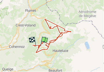

Length
39 km

Max alt
2041 m

Uphill gradient
3191 m
Km-Effort
81 km

Min alt
1321 m

Downhill gradient
3212 m
Boucle
No
Creation date :
2024-02-05 10:06:56.0
Updated on :
2024-02-05 15:43:14.365
4h19
Difficulty : Very easy

FREE GPS app for hiking
 SityTrail
IGN / Geographical institutes
SityTrail Plus
The world is yours!
About
Trail Alpine skiing of 39 km to be discovered at Auvergne-Rhône-Alpes, Savoy, Hauteluce. This trail is proposed by GOHIER.
Description
Beaux paysages et ski cool
Positioning
Country:
France
Region :
Auvergne-Rhône-Alpes
Department/Province :
Savoy
Municipality :
Hauteluce
Location:
Unknown
Start:(Dec)
Start:(UTM)
308575 ; 5070096 (32T) N.
Comments