


La chapelle des pots gr4

taguette
User
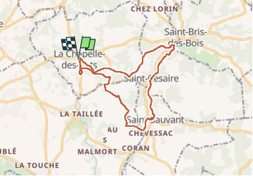

Length
15.7 km

Max alt
74 m

Uphill gradient
186 m
Km-Effort
18.2 km

Min alt
20 m

Downhill gradient
186 m
Boucle
Yes
Creation date :
2024-02-05 12:31:54.214
Updated on :
2024-02-05 16:07:47.987
3h35
Difficulty : Medium

FREE GPS app for hiking
 SityTrail
IGN / Geographical institutes
SityTrail Plus
The world is yours!
About
Trail Walking of 15.7 km to be discovered at New Aquitaine, Charente-Maritime, La Chapelle-des-Pots. This trail is proposed by taguette.
Positioning
Country:
France
Region :
New Aquitaine
Department/Province :
Charente-Maritime
Municipality :
La Chapelle-des-Pots
Location:
Unknown
Start:(Dec)
Start:(UTM)
691181 ; 5070260 (30T) N.
Comments