


SAUBOLE RS 2024

LouisROGER
User GUIDE
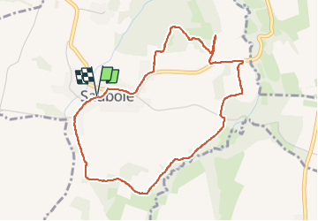

Length
4.9 km

Max alt
393 m

Uphill gradient
74 m
Km-Effort
5.9 km

Min alt
339 m

Downhill gradient
73 m
Boucle
Yes
Creation date :
2024-02-06 12:53:20.825
Updated on :
2024-02-06 15:12:17.589
2h18
Difficulty : Easy

FREE GPS app for hiking
 SityTrail
IGN / Geographical institutes
SityTrail Plus
The world is yours!
About
Trail Walking of 4.9 km to be discovered at New Aquitaine, Pyrénées-Atlantiques, Saubole. This trail is proposed by LouisROGER.
Photos

Positioning
Country:
France
Region :
New Aquitaine
Department/Province :
Pyrénées-Atlantiques
Municipality :
Saubole
Location:
Unknown
Start:(Dec)
Start:(UTM)
733046 ; 4799517 (30T) N.
Comments