


Cognac Jarnac GR 4

taguette
User
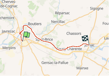

Length
18.5 km

Max alt
34 m

Uphill gradient
134 m
Km-Effort
20 km

Min alt
5 m

Downhill gradient
149 m
Boucle
No
Creation date :
2024-02-08 08:56:11.5
Updated on :
2024-02-08 13:15:54.092
3h52
Difficulty : Difficult

FREE GPS app for hiking
 SityTrail
IGN / Geographical institutes
SityTrail Plus
The world is yours!
About
Trail Walking of 18.5 km to be discovered at New Aquitaine, Charente, Cognac. This trail is proposed by taguette.
Positioning
Country:
France
Region :
New Aquitaine
Department/Province :
Charente
Municipality :
Cognac
Location:
Unknown
Start:(Dec)
Start:(UTM)
708204 ; 5062499 (30T) N.
Comments