Trail Quad Fenioux - Rando 6-7 Avril - Photo
© OpenStreetMap contributors
Length
Length
78 km
Max alt
Max alt
218 m
Uphill gradient
Uphill gradient
1107 m
Km-Effort
Km-Effort  
93 km
Min alt
Min alt
42 m
Downhill gradient
Downhill gradient
1146 m
Boucle
Boucle
No
Creation date :
2024-02-10 06:10:56.087
Updated on :
2024-02-25 04:56:37.447

(0 Reviews)

Quad
Quad
0m
Difficulty : Very easy

Scan this QR Code to open this trail in the SityTrail application

FREE GPS app for hiking

Logo SityTrail SityTrail

IGN / Geographical institutes

Download SityTrail from the App Store Download SityTrail from Google Play

Logo SityTrail SityTrail World

The world is yours!

Download SityTrail from the App Store Download SityTrail from Google Play Download SityTrail on Huawei AppGallery

About

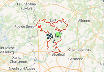
Trail Quad of 78 km to be discovered at New Aquitaine, Deux-Sèvres, Fenioux. This trail is proposed by 001665.dc11d4c9d26f4c3bb58a132eab53c726.0605.

Description

Fenioux- Béceleuf -Ardin-Puy hardy -La Chapelle-Le Busseau-Busseau-la chapelle-le Beugnon-Fenioux

Elevation profile

Points of interest

Point of interest Beugnon-Thireuil - Biere la chapelle - Photo
001665.dc11d4c9d26f4c3bb58a132eab53c726.0605
BEUGNON-THIREUIL 
Point of interest Le Busseau - Gaec la pree - Photo
001665.dc11d4c9d26f4c3bb58a132eab53c726.0605
LE BUSSEAU 
Point of interest Beugnon-Thireuil - Gibaud Patrick - Photo
001665.dc11d4c9d26f4c3bb58a132eab53c726.0605
BEUGNON-THIREUIL 

Positioning

Country:
France
Region :
New Aquitaine
Department/Province :
Deux-Sèvres
Municipality :
Fenioux
Location:
Unknown
Start:(UTM)
690003 ; 5154151 (30T) N.

Trails nearby

Trail Quad Fenioux - randonnée quads  - Photo
Quad
Christopher Dutaud

Quad

Very easy
Fenioux, New Aquitaine, Deux-Sèvres, France
33 km | 40 km-effort
2h 30min
No
Trail Quad Fenioux - amova 2022 - Photo
Quad
Christopher Dutaud

Quad

Easy
(1)
Fenioux, New Aquitaine, Deux-Sèvres, France
64 km | 78 km-effort
5h 3min
No
Trail Walking Ardin - 79 ARDIN du lavoir de Dilay au ruisseau du Saumort - Photo
Walking
maioy

Walking

Medium
Ardin, New Aquitaine, Deux-Sèvres, France
8.5 km | 10.5 km-effort
2h 15min
Yes
Trail Walking Ardin - 79 ARDIN du lavoir de Dilay au ruisseau du Saumort - Photo
Walking
maioy

Walking

Medium
Ardin, New Aquitaine, Deux-Sèvres, France
8.5 km | 10.5 km-effort
2h 15min
Yes
Trail Walking Ardin - Ardin - Photo
Walking
Bushiben

Walking

Very easy
Ardin, New Aquitaine, Deux-Sèvres, France
5.3 km | 6.2 km-effort
2h 39min
Yes
Trail Walking Ardin - Ardin - Photo
Walking
reva17

Walking

Easy
Ardin, New Aquitaine, Deux-Sèvres, France
12.9 km | 15.8 km-effort
3h 39min
Yes
Trail Mountain bike Ardin - Zevtt - Ardin 35 km - Photo
Mountain bike
kipoura

Mountain bike

Medium
Ardin, New Aquitaine, Deux-Sèvres, France
36 km | 42 km-effort
2h 45min
No
Trail Walking Ardin - ardin - Photo
Walking
Carlosenrique

Walking

Medium
Ardin, New Aquitaine, Deux-Sèvres, France
8.8 km | 10.2 km-effort
1h 16min
Yes
Trail Quad Fenioux - rando quad  - Photo
Quad
thomas dupuis

Quad

Medium
Fenioux, New Aquitaine, Deux-Sèvres, France
35 km | 41 km-effort
1h 0min
No


Close
My subscriptions