


randogps46-434

houbart
User
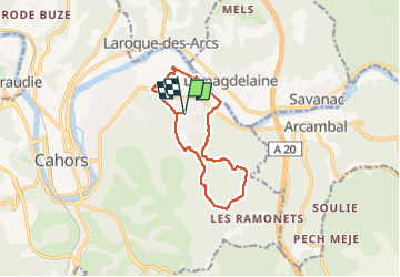

Length
11.8 km

Max alt
288 m

Uphill gradient
262 m
Km-Effort
15.3 km

Min alt
117 m

Downhill gradient
262 m
Boucle
Yes
Creation date :
2024-02-10 10:36:45.818
Updated on :
2024-02-10 10:40:40.802
3h28
Difficulty : Difficult

FREE GPS app for hiking
 SityTrail
IGN / Geographical institutes
SityTrail Plus
The world is yours!
About
Trail Walking of 11.8 km to be discovered at Occitania, Lot, Cahors. This trail is proposed by houbart.
Positioning
Country:
France
Region :
Occitania
Department/Province :
Lot
Municipality :
Cahors
Location:
Unknown
Start:(Dec)
Start:(UTM)
378663 ; 4924041 (31T) N.
Comments