


Châteauneuf sur Charente St Simeux

taguette
User
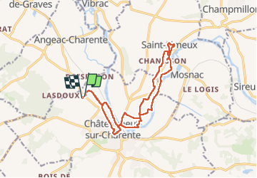

Length
16 km

Max alt
72 m

Uphill gradient
174 m
Km-Effort
18.4 km

Min alt
16 m

Downhill gradient
174 m
Boucle
Yes
Creation date :
2024-02-11 08:39:55.361
Updated on :
2024-02-11 12:10:16.842
3h29
Difficulty : Medium

FREE GPS app for hiking
 SityTrail
IGN / Geographical institutes
SityTrail Plus
The world is yours!
About
Trail Walking of 16 km to be discovered at New Aquitaine, Charente, Châteauneuf-sur-Charente. This trail is proposed by taguette.
Positioning
Country:
France
Region :
New Aquitaine
Department/Province :
Charente
Municipality :
Châteauneuf-sur-Charente
Location:
Unknown
Start:(Dec)
Start:(UTM)
728603 ; 5055030 (30T) N.
Comments