Koestlach - Levoncourt

Alain28/01
User
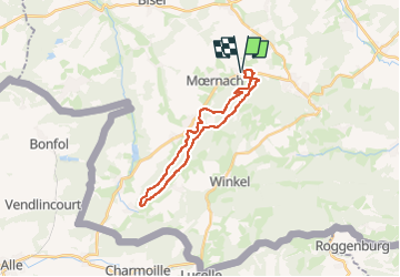

Length
22 km

Max alt
661 m

Uphill gradient
748 m
Km-Effort
32 km

Min alt
457 m

Downhill gradient
748 m
Boucle
Yes
Creation date :
2024-02-11 13:20:36.398
Updated on :
2024-02-11 13:22:07.567
7h10
Difficulty : Medium

FREE GPS app for hiking
 SityTrail
IGN / Geographical institutes
SityTrail Plus
The world is yours!
About
Trail Walking of 22 km to be discovered at Grand Est, Haut-Rhin, Kœstlach. This trail is proposed by Alain28/01.
Positioning
Country:
France
Region :
Grand Est
Department/Province :
Haut-Rhin
Municipality :
Kœstlach
Location:
Unknown
Start:(Dec)
Start:(UTM)
369854 ; 5262894 (32T) N.
Comments