


BALLESTAVY PALOMERA

FAUCET
User
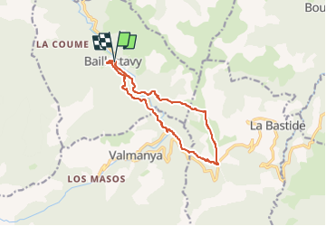

Length
12.2 km

Max alt
1167 m

Uphill gradient
680 m
Km-Effort
21 km

Min alt
585 m

Downhill gradient
679 m
Boucle
Yes
Creation date :
2024-02-11 14:12:34.249
Updated on :
2024-02-11 14:12:35.714
4h49
Difficulty : Very difficult

FREE GPS app for hiking
 SityTrail
IGN / Geographical institutes
SityTrail Plus
The world is yours!
About
Trail Walking of 12.2 km to be discovered at Occitania, Pyrénées-Orientales, Baillestavy. This trail is proposed by FAUCET.
Positioning
Country:
France
Region :
Occitania
Department/Province :
Pyrénées-Orientales
Municipality :
Baillestavy
Location:
Unknown
Start:(Dec)
Start:(UTM)
461112 ; 4712546 (31T) N.
Comments