


Roulet saint Estève GR 4 grp

taguette
User
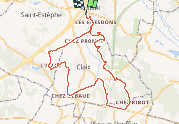

Length
23 km

Max alt
136 m

Uphill gradient
351 m
Km-Effort
27 km

Min alt
44 m

Downhill gradient
352 m
Boucle
Yes
Creation date :
2024-02-13 08:18:19.4
Updated on :
2024-02-13 14:41:16.003
5h17
Difficulty : Difficult

FREE GPS app for hiking
 SityTrail
IGN / Geographical institutes
SityTrail Plus
The world is yours!
About
Trail Walking of 23 km to be discovered at New Aquitaine, Charente, Roullet-Saint-Estèphe. This trail is proposed by taguette.
Positioning
Country:
France
Region :
New Aquitaine
Department/Province :
Charente
Municipality :
Roullet-Saint-Estèphe
Location:
Unknown
Start:(Dec)
Start:(UTM)
269439 ; 5051660 (31T) N.
Comments