


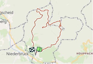
Sickert Eglise-Luttersberg-Abris près de Sickertbach-Obersickert-Eglise Sickert

patrickbeyrath
User

Length
9.1 km

Max alt
748 m

Uphill gradient
348 m
Km-Effort
13.7 km

Min alt
428 m

Downhill gradient
348 m
Boucle
Yes
Creation date :
2018-10-13 05:52:44.438
Updated on :
2018-10-13 05:52:44.446
3h03
Difficulty : Medium

FREE GPS app for hiking
 SityTrail
IGN / Geographical institutes
SityTrail Plus
The world is yours!
About
Trail Walking of 9.1 km to be discovered at Grand Est, Haut-Rhin, Sickert. This trail is proposed by patrickbeyrath.
Positioning
Country:
France
Region :
Grand Est
Department/Province :
Haut-Rhin
Municipality :
Sickert
Location:
Unknown
Start:(Dec)
Start:(UTM)
348615 ; 5294138 (32T) N.
Comments