Trail Walking M'Hamid El Ghizlane - 21 fev Bounou Zagora  - Photo
 michcoq
michcoq

User

© OpenStreetMap contributors
Length
Length
119 km
Max alt
Max alt
857 m
Uphill gradient
Uphill gradient
928 m
Km-Effort
Km-Effort  
131 km
Min alt
Min alt
558 m
Downhill gradient
Downhill gradient
773 m
Boucle
Boucle
No
Creation date :
2024-02-21 08:21:53.35
Updated on :
2024-02-25 08:19:48.298

(0 Reviews)

Walking
Walking
8h37
Difficulty : Medium
Car
Car
0m
Difficulty : Medium

Scan this QR Code to open this trail in the SityTrail application

FREE GPS app for hiking

Logo SityTrail SityTrail

IGN / Geographical institutes

Download SityTrail from the App Store Download SityTrail from Google Play

Logo SityTrail SityTrail World

The world is yours!

Download SityTrail from the App Store Download SityTrail from Google Play Download SityTrail on Huawei AppGallery

About

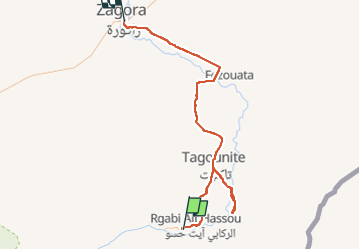
Trail Walking of 119 km to be discovered at Drâa-Tafilalet, cercle de Zagora, M'Hamid El Ghizlane. This trail is proposed by michcoq.

Description

rando en milieu de trajet voiture

Elevation profile

Photos

Positioning

Country:
Morocco
Region :
Drâa-Tafilalet
Department/Province :
cercle de Zagora
Municipality :
M'Hamid El Ghizlane
Location:
Unknown
Start:(UTM)
242338 ; 3302588 (30R) N.

Trails nearby

Trail Walking M'Hamid El Ghizlane - 20 fev rando depuis
Walking
michcoq

Walking

Easy
M'Hamid El Ghizlane, Drâa-Tafilalet, cercle de Zagora, Morocco
16.4 km | 17.6 km-effort
7h 10min
Yes
Trail Motorbike M'Hamid El Ghizlane - jour 7  - Photo
Motorbike
pir911

Motorbike

Very easy
M'Hamid El Ghizlane, Drâa-Tafilalet, cercle de Zagora, Morocco
113 km | 124 km-effort
5h 28min
Yes


Close
My subscriptions