


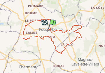
Fouquebrune grp GR 4

taguette
User

Length
19.5 km

Max alt
200 m

Uphill gradient
241 m
Km-Effort
23 km

Min alt
118 m

Downhill gradient
241 m
Boucle
Yes
Creation date :
2024-02-15 07:16:40.427
Updated on :
2024-02-24 08:20:17.089
4h03
Difficulty : Difficult

FREE GPS app for hiking
 SityTrail
IGN / Geographical institutes
SityTrail Plus
The world is yours!
About
Trail Walking of 19.5 km to be discovered at New Aquitaine, Charente, Fouquebrune. This trail is proposed by taguette.
Positioning
Country:
France
Region :
New Aquitaine
Department/Province :
Charente
Municipality :
Fouquebrune
Location:
Unknown
Start:(Dec)
Start:(UTM)
282030 ; 5045342 (31T) N.
Comments