


Autour de novalaise

choubaka77
User
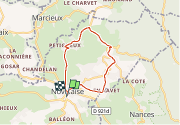

Length
6 km

Max alt
650 m

Uphill gradient
225 m
Km-Effort
9 km

Min alt
422 m

Downhill gradient
228 m
Boucle
Yes
Creation date :
2024-02-24 14:24:34.0
Updated on :
2024-02-24 15:57:33.504
1h32
Difficulty : Very easy

FREE GPS app for hiking
 SityTrail
IGN / Geographical institutes
SityTrail Plus
The world is yours!
About
Trail Walking of 6 km to be discovered at Auvergne-Rhône-Alpes, Savoy, Novalaise. This trail is proposed by choubaka77.
Description
Petite boucle d’après-midi d’hiver
Positioning
Country:
France
Region :
Auvergne-Rhône-Alpes
Department/Province :
Savoy
Municipality :
Novalaise
Location:
Unknown
Start:(Dec)
Start:(UTM)
716088 ; 5052684 (31T) N.
Comments