


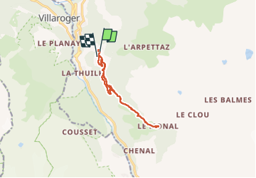
Le Monal

LauVan
User

Length
10.9 km

Max alt
1877 m

Uphill gradient
445 m
Km-Effort
16.8 km

Min alt
1494 m

Downhill gradient
436 m
Boucle
Yes
Creation date :
2024-02-26 10:08:08.573
Updated on :
2024-02-26 15:11:32.539
4h58
Difficulty : Medium

FREE GPS app for hiking
 SityTrail
IGN / Geographical institutes
SityTrail Plus
The world is yours!
About
Trail Snowshoes of 10.9 km to be discovered at Auvergne-Rhône-Alpes, Savoy, Sainte-Foy-Tarentaise. This trail is proposed by LauVan.
Positioning
Country:
France
Region :
Auvergne-Rhône-Alpes
Department/Province :
Savoy
Municipality :
Sainte-Foy-Tarentaise
Location:
Unknown
Start:(Dec)
Start:(UTM)
335706 ; 5049518 (32T) N.
Comments