


2024-02-27_15h30m11_A9

LUTZMarc
User

Length
17 km

Max alt
379 m

Uphill gradient
388 m
Km-Effort
22 km

Min alt
220 m

Downhill gradient
390 m
Boucle
Yes
Creation date :
2024-02-27 14:30:11.897
Updated on :
2024-11-01 08:35:56.406
5h02
Difficulty : Easy

FREE GPS app for hiking
 SityTrail
IGN / Geographical institutes
SityTrail Plus
The world is yours!
About
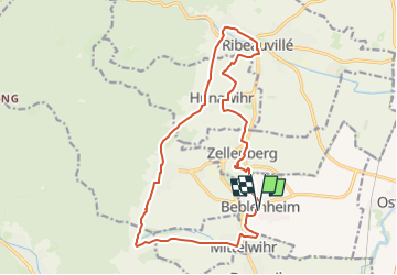
Trail Walking of 17 km to be discovered at Grand Est, Haut-Rhin, Beblenheim. This trail is proposed by LUTZMarc.
Description
A faire au printemps quand les amandiers sont en fleurs.
Resto à Ribeauvillé.
Positioning
Country:
France
Region :
Grand Est
Department/Province :
Haut-Rhin
Municipality :
Beblenheim
Location:
Unknown
Start:(Dec)
Start:(UTM)
375441 ; 5335212 (32U) N.
Comments