


montée aux Galtz de Turckheim

OxygenLT
User
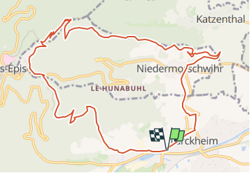

Length
13.1 km

Max alt
720 m

Uphill gradient
545 m
Km-Effort
20 km

Min alt
239 m

Downhill gradient
539 m
Boucle
Yes
Creation date :
2024-03-02 10:56:32.351
Updated on :
2024-03-06 08:16:41.497
4h37
Difficulty : Very difficult

FREE GPS app for hiking
 SityTrail
IGN / Geographical institutes
SityTrail Plus
The world is yours!
About
Trail Walking of 13.1 km to be discovered at Grand Est, Haut-Rhin, Turckheim. This trail is proposed by OxygenLT.
Positioning
Country:
France
Region :
Grand Est
Department/Province :
Haut-Rhin
Municipality :
Turckheim
Location:
Unknown
Start:(Dec)
Start:(UTM)
371283 ; 5327331 (32U) N.
Comments