


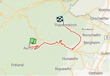
De Aubure à Tannenkirch

Regisconraud
User

Length
21 km

Max alt
801 m

Uphill gradient
566 m
Km-Effort
29 km

Min alt
250 m

Downhill gradient
882 m
Boucle
No
Creation date :
2024-03-07 07:32:01.366
Updated on :
2024-03-08 16:27:49.126
7h51
Difficulty : Very difficult

FREE GPS app for hiking
 SityTrail
IGN / Geographical institutes
SityTrail Plus
The world is yours!
About
Trail Walking of 21 km to be discovered at Grand Est, Haut-Rhin, Aubure. This trail is proposed by Regisconraud.
Positioning
Country:
France
Region :
Grand Est
Department/Province :
Haut-Rhin
Municipality :
Aubure
Location:
Unknown
Start:(Dec)
Start:(UTM)
367816 ; 5339848 (32U) N.
Comments