


Hauteluce 6km

pmauvieux
User
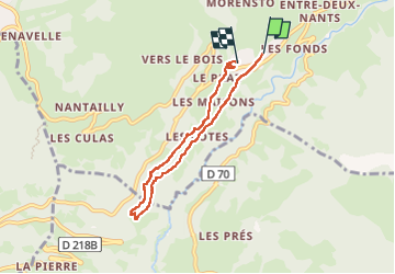

Length
5.9 km

Max alt
1173 m

Uphill gradient
233 m
Km-Effort
8.9 km

Min alt
971 m

Downhill gradient
209 m
Boucle
No
Creation date :
2024-03-10 13:39:05.685
Updated on :
2024-03-10 15:42:54.599
1h52
Difficulty : Medium

FREE GPS app for hiking
 SityTrail
IGN / Geographical institutes
SityTrail Plus
The world is yours!
About
Trail Walking of 5.9 km to be discovered at Auvergne-Rhône-Alpes, Savoy, Hauteluce. This trail is proposed by pmauvieux.
Positioning
Country:
France
Region :
Auvergne-Rhône-Alpes
Department/Province :
Savoy
Municipality :
Hauteluce
Location:
Unknown
Start:(Dec)
Start:(UTM)
312135 ; 5069133 (32T) N.
Comments