


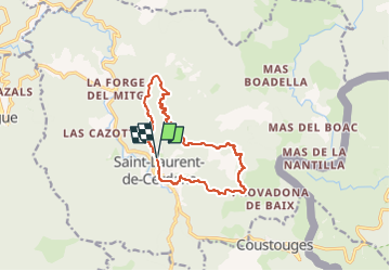
la broussard de Saint Laurent

FAUCET
User

Length
13 km

Max alt
914 m

Uphill gradient
453 m
Km-Effort
19 km

Min alt
649 m

Downhill gradient
450 m
Boucle
Yes
Creation date :
2024-03-12 16:14:46.269
Updated on :
2024-03-12 16:14:47.788
4h18
Difficulty : Difficult

FREE GPS app for hiking
 SityTrail
IGN / Geographical institutes
SityTrail Plus
The world is yours!
About
Trail Walking of 13 km to be discovered at Occitania, Pyrénées-Orientales, Saint-Laurent-de-Cerdans. This trail is proposed by FAUCET.
Positioning
Country:
France
Region :
Occitania
Department/Province :
Pyrénées-Orientales
Municipality :
Saint-Laurent-de-Cerdans
Location:
Unknown
Start:(Dec)
Start:(UTM)
468155 ; 4692929 (31T) N.
Comments